
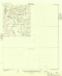
1931 Map of Iola
USGS Topo · Published 1931About this map
The Navasota River carves a winding path through the center of this 1925 survey area, defining the boundaries of Robertson, Leon, Madison, and Brazos counties. This landscape is characterized by a series of oxbow lakes and seasonal basins, including San Antonio L, Donahoe L, and Duck L, which dot the river’s floodplain. Settlement patterns are sparse, represented by small social and educational hubs like Burns Store, Plain View Sch, and Bundy Sch.
Find a feature on this map
24 named features on this map. Tap any name to fly to it.
Don’t see what you’re looking for? This feature index may not catch every label — zoom into the map to look around manually.
Map Details
Editions of this 1931 Iola Map
2 editions found
Other maps of this area

1925 · Iola No 2
USGS Topo · 1:48,000

1925 · Marquez No. 4
USGS Topo · 1:48,000

1927 · Marquez
USGS Topo · 1:62,500

1930 · Marquez
USGS Topo · 1:62,500

1953 · Palestine
USGS Topo · 1:250,000

1954 · Waco
USGS Topo · 1:250,000

1954 · Beaumont
USGS Topo · 1:250,000

1954 · Austin
USGS Topo · 1:250,000

1955 · Waco
USGS Topo · 1:250,000

1956 · Bryan
USGS Topo · 1:62,500