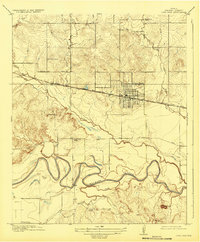
1918 Map of Iowa Park
USGS Topo · Published 1932About this map
The Iowa Park townsite is defined by a rigorous grid just north of the Fort Worth and Denver City railroad line. Surveyed during the First World War, this landscape in Wichita County shows a transition between the established town and a network of outlying rural communities. The meanders of the Wichita River dominate the southern portion of the map, carving deep bends across the plains. This era of settlement is marked by a high density of rural schoolhouses, including Deep Creek School, Pond Creek School, Harmony School, Cobb School, and Denny School, which served the farming families established along the drainage of Buffalo Creek and Antelope Creek. Local travel is anchored by early arterial routes like the Electra Road and Wichita Falls Road, while Bare Butte provides a rare topographic landmark in an otherwise subtly rolling terrain.
Find a feature on this map
21 named features on this map. Tap any name to fly to it.
Don’t see what you’re looking for? This feature index may not catch every label — zoom into the map to look around manually.
Map Details
Editions of this 1918 Iowa Park Map
2 editions found
Other maps of this area

1915 · Clara
USGS Topo · 1:24,000

1915 · Barwise School
USGS Topo · 1:24,000

1915 · Burkburnett
USGS Topo · 1:24,000

1916 · Iowa Park
USGS Topo · 1:24,000

1916 · Fowlkes
USGS Topo · 1:24,000

1918 · Buckburnett
USGS Topo · 1:31,680

1918 · Barwise School
USGS Topo · 1:31,680

1918 · Clara
USGS Topo · 1:31,680

1918 · Iowa Park
USGS Topo · 1:31,680

1919 · Fowlkes
USGS Topo · 1:31,680