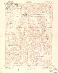
1948 Map of Ipava
USGS Topo · Published 1948About this map
The Camp Ellis Military Reservation occupies the northern reaches of this landscape shortly after the end of World War II, showing its extensive barracks, a Sewage Disposal plant, and the Camp Ellis Landing Strip. This military presence contrasts with the surrounding agricultural townships of Bernadotte, Farmer, and Pleasant, where the Chicago Burlington and Quincy railroad connects the village of Ipava to the wider region.
Find a feature on this map
33 named features on this map. Tap any name to fly to it.
Don’t see what you’re looking for? This feature index may not catch every label — zoom into the map to look around manually.
Map Details
Editions of this 1948 Ipava Map
3 editions found
Other maps of this area

1918 · Vermont
USGS Topo · 1:62,500

1921 · Vermont
USGS Topo · 1:62,500

1925 · Havana
USGS Topo · 1:62,500

1926 · Beardstown
USGS Topo · 1:62,500

1930 · Chandlerville
USGS Topo · 1:62,500

1932 · Chandlerville
USGS Topo · 1:62,500

1944 · Beardstown
USGS Topo · 1:62,500

1947 · Lewistown
USGS Topo · 1:24,000

1947 · Vermont
USGS Topo · 1:24,000

1947 · Adair
USGS Topo · 1:24,000