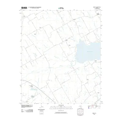
2010 Map of Irene
USGS Topo · Published 2010About this map
Navarro Mills Lake dominates the eastern landscape of this Hill and Navarro County border region, where the prairie transitions into a network of creek drainages. The small settlements of Irene, Pelham, Emmett, and Brushie Prairie are connected by a web of rural routes like FM 1946 and numerous county roads. This area is deeply tied to its agricultural roots, evidenced by the scattered distribution of family and community burial grounds including Salem Cemetery, Graham Cemetery, and Antioch Cemetery. The hydrological profile is defined by winding watercourses such as Richland Creek, White Rock Creek, and Ash Creek, which feed into the primary reservoir. Land management efforts are visible through the Soil Conservation Service Site 89 Reservoir and associated dams, which regulate the flow of Little Cottonwood Creek and Cottonwood Creek in the southwestern quadrant.
Find a feature on this map
60 named features on this map. Tap any name to fly to it.
Don’t see what you’re looking for? This feature index may not catch every label — zoom into the map to look around manually.
Map Details
Editions of this 2010 Irene Map
This is the sole edition of this map. No revisions or reprints were ever made.
Other maps of this area

1954 · Dallas
USGS Topo · 1:250,000

1954 · Waco
USGS Topo · 1:250,000

1955 · Waco
USGS Topo · 1:250,000

1956 · Hubbard
USGS Topo · 1:24,000

1956 · Penelope
USGS Topo · 1:24,000

1956 · Dawson
USGS Topo · 1:24,000

1957 · Irene
USGS Topo · 1:24,000
1957 · Malone
USGS Topo · 1:24,000

1958 · Dallas
USGS Topo · 1:250,000

1965 · Coolidge
USGS Topo · 1:24,000