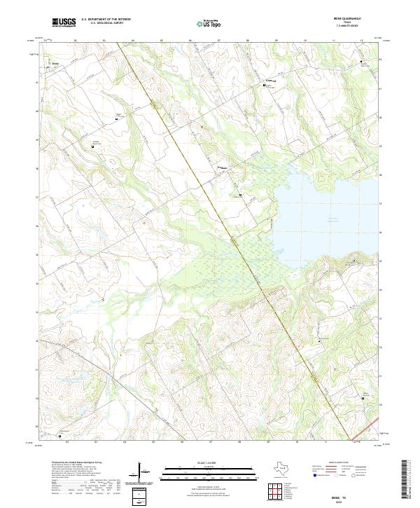
2022 Map of Irene
USGS Topo · Published 2022About this map
Irene sits at the northwestern edge of this Hill County landscape, where the agricultural plains transition into the drainage basins of Richland Cr and White Rock Cr. The terrain is defined by a dense network of country roads and numerous small family and community burial grounds, such as the Salem - Irene Cem and the Graham - Mason Cem, which highlight the deeply rooted settlement patterns of the region. The southeastern portion of the map is dominated by the waters of Navarro Mills Lake, a significant geographical feature where the Hill Co and Navarro Co line intersects the reservoir. Small rural centers like Pelham and Emmett are connected by routes such as FM 744, serving as focal points for the surrounding farmsteads. The mapping of Soil Conservation Service Site 89 Reservoir and various branches like Treadwell Br underscores the importance of water management in this rural Texas environment.
Find a feature on this map
85 named features on this map. Tap any name to fly to it.
Don’t see what you’re looking for? This feature index may not catch every label — zoom into the map to look around manually.
Map Details
Editions of this 2022 Irene Map
This is the sole edition of this map. No revisions or reprints were ever made.
Other maps of this area

1954 · Dallas
USGS Topo · 1:250,000

1954 · Waco
USGS Topo · 1:250,000

1955 · Waco
USGS Topo · 1:250,000

1956 · Hubbard
USGS Topo · 1:24,000

1956 · Penelope
USGS Topo · 1:24,000

1956 · Dawson
USGS Topo · 1:24,000

1957 · Irene
USGS Topo · 1:24,000
1957 · Malone
USGS Topo · 1:24,000

1958 · Dallas
USGS Topo · 1:250,000

1965 · Coolidge
USGS Topo · 1:24,000