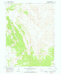
1966 Map of Irish Canyon
USGS Topo · Published 1978About this map
Cold Spring Mountain and the prominent Limestone Ridge dominate this corner of Moffat County, framing the deep incision of Irish Canyon. Surveyed in the mid-1960s, the landscape reflects a high-desert environment defined more by its relief and drainage patterns than by dense settlement. Vermillion Creek and Dry Creek cut through the terrain, leading toward the southern reaches of the quadrangle where the only named habitation, Ink Springs Ranch, is situated near a seasonal Spring. The map documents a sparsely populated ranching and extraction landscape, evidenced by the presence of a Gravel Pit and the small catchments of the Irish Lakes near Blue Hill. It serves as a detailed record of the northwestern Colorado backcountry during a period of minimal cultural change.
Find a feature on this map
10 named features on this map. Tap any name to fly to it.
Don’t see what you’re looking for? This feature index may not catch every label — zoom into the map to look around manually.
Map Details
Editions of this 1966 Irish Canyon Map
3 editions found
Other maps of this area

1954 · Vernal
USGS Topo · 1:250,000

1958 · Vernal
USGS Topo · 1:250,000

1960 · Vernal
USGS Topo · 1:250,000

1966 · G Spring
USGS Topo · 1:24,000

1966 · Sugarloaf Butte
USGS Topo · 1:24,000

1966 · Big Joe Basin
USGS Topo · 1:24,000
1966 · Sparks
USGS Topo · 1:24,000

1966 · Irish Canyon
USGS Topo · 1:24,000

1966 · Sheephead Basin
USGS Topo · 1:24,000

1966 · Hiawatha
USGS Topo · 1:24,000