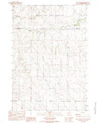
1983 Map of Irish Creek NE
USGS Topo · Published 1983About this map
The Standing Rock Indian Reservation occupies the northern half of this landscape, meeting the Cheyenne River Indian Reservation Boundary at the line between Corson and Ziebach counties. The terrain is defined by the winding drainages of Firesteel Creek in the north and Red Earth Creek further south, illustrating the vast open spaces of the Dakotas during the early 1980s. This survey, compiled from 1975 aerial photography, provides a clear view of the rural infrastructure, specifically the early network of unimproved roads and trails that traverse the reservation lands. The absence of concentrated settlements emphasizes the agricultural and pastoral nature of the region during this era, making it a valuable resource for understanding the land-use patterns across these sovereign tribal territories.
Find a feature on this map
5 named features on this map. Tap any name to fly to it.
Don’t see what you’re looking for? This feature index may not catch every label — zoom into the map to look around manually.
Map Details
Editions of this 1983 Irish Creek NE Map
2 editions found
Other maps of this area

1953 · McIntosh
USGS Topo · 1:250,000

1956 · Black Horse SW
USGS Topo · 1:24,000

1956 · Cottonwood Creek SE
USGS Topo · 1:24,000

1956 · Cottonwood Creek SW
USGS Topo · 1:24,000

1958 · McIntosh
USGS Topo · 1:250,000

1978 · Isabel SW
USGS Topo · 1:24,000

1978 · Isabel
USGS Topo · 1:24,000

1980 · McIntosh
USGS Topo · 1:100,000

1982 · Irish Creek SW
USGS Topo · 1:24,000
1982 · Irish Creek NW
USGS Topo · 1:24,000