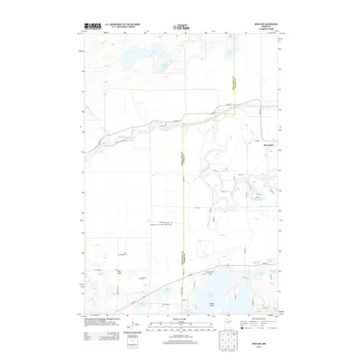
2013 Map of Iron Hub
USGS Topo · Published 2013About this map
The winding Mississippi River carves a deep path through the central landscape of this Aitkin and Crow Wing County border region. Along its banks, the small settlement of Pine Knoll stands near a sharp river bend, while the namesake Iron Hub lies to the southwest, connected by a network of local roads such as Iron Hub Rd. The terrain is characterized by numerous glacial water bodies, including the expansive Cedar Lake featuring Grape Island, and smaller named waters like Rushmeyer Lake and Casey Lake.
Find a feature on this map
61 named features on this map. Tap any name to fly to it.
Don’t see what you’re looking for? This feature index may not catch every label — zoom into the map to look around manually.
Map Details
Editions of this 2013 Iron Hub Map
This is the sole edition of this map. No revisions or reprints were ever made.
Other maps of this area

1912 · Deerwood
USGS Topo · 1:62,500

1913 · Cuyuna
USGS Topo · 1:62,500

1914 · Deerwood
USGS Topo · 1:62,500

1914 · Aitkin
USGS Topo · 1:62,500

1915 · Aitkin
USGS Topo · 1:62,500

1915 · Cuyuna
USGS Topo · 1:62,500

1916 · Wealthwood
USGS Topo · 1:62,500

1953 · Duluth
USGS Topo · 1:250,000

1958 · Duluth
USGS Topo · 1:250,000
1973 · Emily
USGS Topo · 1:24,000