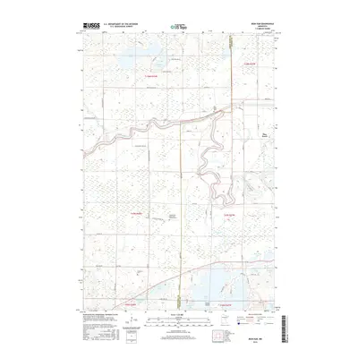
2016 Map of Iron Hub
USGS Topo · Published 2016About this map
The Mississippi River winds through a landscape defined by glacial lakes and low-lying wetlands along the border of Crow Wing and Aitkin counties. This area is characterized by scattered small settlements like Iron Hub and Pine Knoll, where rural roads like Paddy Ave and Sullivan Lake Rd connect isolated homesteads and cemeteries. The map reveals a high density of small burial grounds that serve these rural communities, including Cedarbrook - Saint John's Lutheran Cem and Immanuel Cem.
Find a feature on this map
70 named features on this map. Tap any name to fly to it.
Don’t see what you’re looking for? This feature index may not catch every label — zoom into the map to look around manually.
Map Details
Editions of this 2016 Iron Hub Map
This is the sole edition of this map. No revisions or reprints were ever made.
Other maps of this area

1912 · Deerwood
USGS Topo · 1:62,500

1913 · Cuyuna
USGS Topo · 1:62,500

1914 · Deerwood
USGS Topo · 1:62,500

1914 · Aitkin
USGS Topo · 1:62,500

1915 · Aitkin
USGS Topo · 1:62,500

1915 · Cuyuna
USGS Topo · 1:62,500

1916 · Wealthwood
USGS Topo · 1:62,500

1953 · Duluth
USGS Topo · 1:250,000

1958 · Duluth
USGS Topo · 1:250,000
1973 · Emily
USGS Topo · 1:24,000