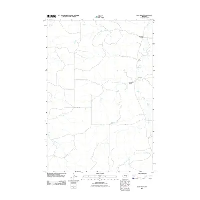
2011 Map of Iron Spring
USGS Topo · Published 2011About this map
Sarpy Creek and its many offshoot coulees carve a complex drainage pattern through this Treasure County landscape, defining the rural character of the region. The map documents a sparsely populated ranching environment where life is organized around vital water sources and vast cattle operations such as Hammond Ranch and Padlock Ranch. Significant local landmarks like Iron Spring and the Wolf School represent the essential social and natural anchors for the small community of Walt and its surrounding homesteads. The terrain is marked by a series of named ravines, including Rainwater Coulee and Coxs Coulee, illustrating the intricate topography of the high plains. Reliable routes such as Iron Spring Rd and Sarpy Rd provide the primary connections through this area of eastern Montana, where the names of early settlers are preserved in the various coulees that feed into the larger creek systems.
Find a feature on this map
19 named features on this map. Tap any name to fly to it.
Don’t see what you’re looking for? This feature index may not catch every label — zoom into the map to look around manually.
Map Details
Editions of this 2011 Iron Spring Map
This is the sole edition of this map. No revisions or reprints were ever made.
Other maps of this area

1954 · Hardin
USGS Topo · 1:250,000

1954 · Forsyth
USGS Topo · 1:250,000

1957 · Hardin
USGS Topo · 1:250,000

1957 · Forsyth
USGS Topo · 1:250,000

1958 · Forsyth
USGS Topo · 1:250,000

1958 · Hardin
USGS Topo · 1:250,000

1960 · Hope Ranch
USGS Topo · 1:24,000

1972 · Hammond Ranch
USGS Topo · 1:24,000

1972 · Minnehaha Creek South
USGS Topo · 1:24,000
1972 · Minnehaha Creek North
USGS Topo · 1:24,000