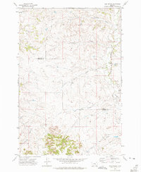
1972 Map of Iron Spring
USGS Topo · Published 1975About this map
The Red Hills rise above a landscape defined by an intricate network of coulees and seasonal drainages along the border of Treasure and Big Horn counties. In the early 1970s, this portion of Montana remained primarily open rangeland, marked by isolated infrastructure such as a substation and various gravel pits. The Burlington Northern railroad corridor follows the path of Sarpy Creek in the eastern section of the map, providing a vital transportation link through this sparsely populated territory. Numerous named water features like Iron Spring, Kray Coulee Spring, and Cottonwood Creek indicate the critical importance of water sources in this arid terrain. The presence of several drill holes and wells suggests ongoing resource exploration or agricultural development during this period of the twentieth century.
Find a feature on this map
19 named features on this map. Tap any name to fly to it.
Don’t see what you’re looking for? This feature index may not catch every label — zoom into the map to look around manually.
Map Details
Editions of this 1972 Iron Spring Map
This is the sole edition of this map. No revisions or reprints were ever made.
Other maps of this area

1954 · Hardin
USGS Topo · 1:250,000

1954 · Forsyth
USGS Topo · 1:250,000

1957 · Hardin
USGS Topo · 1:250,000

1957 · Forsyth
USGS Topo · 1:250,000

1958 · Forsyth
USGS Topo · 1:250,000

1958 · Hardin
USGS Topo · 1:250,000

1960 · Hope Ranch
USGS Topo · 1:24,000

1972 · Hammond Ranch
USGS Topo · 1:24,000

1972 · Minnehaha Creek South
USGS Topo · 1:24,000
1972 · Minnehaha Creek North
USGS Topo · 1:24,000