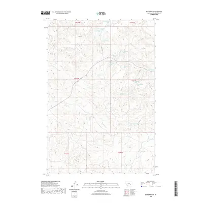
2020 Map of Iron Spring SW
USGS Topo · Published 2020About this map
Red Hills dominates the northern landscape of this Big Horn County terrain, where a complex network of drainage basins defines the land use and movement. The area is characterized by an exceptional density of natural water sources, including dozens of specific springs such as 01N36E01ABCD01 Spring and 01N37E07BACC01 Spring. These water points support a series of vital waterways like Plum Cr, Sarpy Cr, and E Cabin Cr that carve through the high plains. The transition between the township and range lines of t1n r36e and t1n r37e is navigated by rural routes like Iron Springs Rd and Romine Dr, reflecting a landscape dedicated to ranching and resource management where water is the primary driver of human presence.
Find a feature on this map
28 named features on this map. Tap any name to fly to it.
Don’t see what you’re looking for? This feature index may not catch every label — zoom into the map to look around manually.
Map Details
Editions of this 2020 Iron Spring SW Map
This is the sole edition of this map. No revisions or reprints were ever made.
Other maps of this area

1954 · Hardin
USGS Topo · 1:250,000

1957 · Hardin
USGS Topo · 1:250,000

1958 · Hardin
USGS Topo · 1:250,000

1967 · Jeans Fork NW
USGS Topo · 1:24,000

1967 · Jeans Fork NE
USGS Topo · 1:24,000

1967 · Crow Agency NE
USGS Topo · 1:24,000

1972 · Hammond Ranch
USGS Topo · 1:24,000

1972 · Minnehaha Creek South
USGS Topo · 1:24,000
1972 · Iron Spring
USGS Topo · 1:24,000
1972 · Padlock Ranch
USGS Topo · 1:24,000