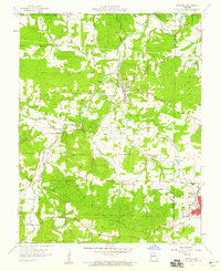
1958 Map of Irondale
USGS Topo · Published 1959About this map
Big River carves a winding path through this corner of the Ozarks, serving as the geographic anchor for the town of Irondale. The landscape is a complex intersection of mining activity and small-town Missouri life in the late 1950s. Industrial heritage is evident in the numerous labeled diggings, such as Evans Mine, Irondale Mine, and the Hayden Creek Mine to the northeast. To the southeast, the settlement of Bismarek sits along the Missouri Pacific railroad line, which provided a vital transportation link for the region's mineral resources. Local genealogy and community life are well-documented through several family and rural landmarks. Genealogists can locate sites like Wallen Cem, Big River Cem, and Davis Cem, while the presence of Hickory Grove Ch and Camp Irondale suggests the social and recreational fabric of the area during this era.
Find a feature on this map
31 named features on this map. Tap any name to fly to it.
Don’t see what you’re looking for? This feature index may not catch every label — zoom into the map to look around manually.
Map Details
Editions of this 1958 Irondale Map
3 editions found
Other maps of this area

1905 · Bonneterre
USGS Topo · 1:62,500

1906 · Potosi
USGS Topo · 1:62,500

1924 · Edgehill
USGS Topo · 1:62,500

1926 · Edgehill
USGS Topo · 1:62,500

1937 · Ironton
USGS Topo · 1:48,000

1945 · Ironton
USGS Topo · 1:62,500

1946 · Ironton
USGS Topo · 1:62,500

1949 · Rolla
USGS Topo · 1:250,000

1953 · Ironton
USGS Topo · 1:62,500

1953 · Rolla
USGS Topo · 1:250,000