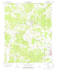
1958 Map of Irondale
USGS Topo · Published 1968About this map
Big River flows through the heart of the eastern Ozarks, carving a path between the prominent heights of Hughes Mountain and Round Mountain. In the late 1950s, the landscape here was defined by a mix of lead mining history and rural community life. The Missouri Pacific railroad connects the primary settlements of Irondale and Bismarck, passing through the rugged Clark National Forest near the St. Francois County line. Evidence of the region’s mineral wealth is scattered across the terrain, from the Irondale Mine to the Hayden Creek Mine and Evans Mine. Local social and religious centers are grounded in landmarks like Hickory Grove Ch and the Camp Irondale, while family histories are preserved at Wallen Cem, Davis Cem, and Big River Cem. Small tributaries including Wallen Creek and Hopewell Creek drain into the main river valley, illustrating the drainage patterns that shaped local settlement.
Find a feature on this map
40 named features on this map. Tap any name to fly to it.
Don’t see what you’re looking for? This feature index may not catch every label — zoom into the map to look around manually.
Map Details
Editions of this 1958 Irondale Map
3 editions found
Other maps of this area

1905 · Bonneterre
USGS Topo · 1:62,500

1906 · Potosi
USGS Topo · 1:62,500

1924 · Edgehill
USGS Topo · 1:62,500

1926 · Edgehill
USGS Topo · 1:62,500

1937 · Ironton
USGS Topo · 1:48,000

1945 · Ironton
USGS Topo · 1:62,500

1946 · Ironton
USGS Topo · 1:62,500

1949 · Rolla
USGS Topo · 1:250,000

1953 · Ironton
USGS Topo · 1:62,500

1953 · Rolla
USGS Topo · 1:250,000