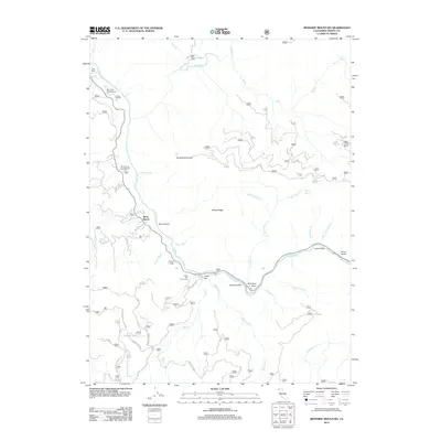
2012 Map of Ironside Mountain
USGS Topo · Published 2012About this map
The Trinity River carves a dramatic path through this 2012 survey of Trinity County, defining a landscape of steep elevation changes and narrow canyons. Settled points like Burnt Ranch and Gray Ranch anchor the river corridor, which is characterized by historical river bars and natural obstacles including Box Canyon and the massive China Slide. The map documents a rugged network of forest service roads and trails, such as Underwood Mountain Rd and Hidden Lake Rd, that lead to isolated landmarks like Hidden Lake and Ironside Mountain. Along the water, recreational sites such as Gray Falls Campground and the Cedar Flat Picnic Area provide access to the river's unique features, from the turbulence of Burnt Ranch Falls and Gray Falls to quiet tributaries like Don Juan Cr and Smoky Camp Cr. Named bars including New York Bar and Luccock Bar speak to the region's long history of river-based activity.
Find a feature on this map
67 named features on this map. Tap any name to fly to it.
Don’t see what you’re looking for? This feature index may not catch every label — zoom into the map to look around manually.
Map Details
Editions of this 2012 Ironside Mountain Map
This is the sole edition of this map. No revisions or reprints were ever made.
Other maps of this area

1909 · Big Bar
USGS Topo · 1:96,000

1914 · Pilot Creek
USGS Topo · 1:62,500

1915 · Big Bar and Vicinity
USGS Topo · 1:250,000

1922 · China Flat
USGS Topo · 1:62,500

1951 · Pilot Creek
USGS Topo · 1:62,500

1951 · Hyampom
USGS Topo · 1:62,500

1951 · Ironside Mountain
USGS Topo · 1:62,500

1952 · Willow Creek
USGS Topo · 1:62,500

1958 · Redding
USGS Topo · 1:250,000
1979 · Salyer
USGS Topo · 1:24,000