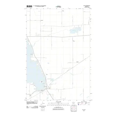
2010 Map of Isle
USGS Topo · Published 2010About this map
The southeastern shores of Mille Lacs Lake are anchored by the town of Isle, where the landscape transitions from open water to a network of creeks and small interior lakes. This 2010 survey shows the area's established residential and agricultural grid, punctuated by landmarks such as Isle Airport and the transition of the former railroad corridor into the Soo Line Trl. The map provides significant detail for genealogists, identifying five distinct burial grounds including Holden Cemetery in the north and the cluster of Isle Cemetery, Sunset Cemetery, and Sacred Heart Cemetery near the town center.
Find a feature on this map
43 named features on this map. Tap any name to fly to it.
Don’t see what you’re looking for? This feature index may not catch every label — zoom into the map to look around manually.
Map Details
Editions of this 2010 Isle Map
This is the sole edition of this map. No revisions or reprints were ever made.
Other maps of this area

1916 · Wealthwood
USGS Topo · 1:62,500

1953 · Duluth
USGS Topo · 1:250,000

1958 · Duluth
USGS Topo · 1:250,000

1968 · Isle SW
USGS Topo · 1:24,000

1968 · Wahkon North
USGS Topo · 1:24,000

1968 · Isle
USGS Topo · 1:24,000

1968 · Warman
USGS Topo · 1:24,000
1968 · Wahkon South
USGS Topo · 1:24,000

1968 · Mc Grath
USGS Topo · 1:24,000

1969 · Thor SE
USGS Topo · 1:24,000