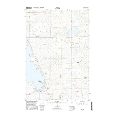
2016 Map of Isle
USGS Topo · Published 2016About this map
Isle anchors the southeastern shoreline of Mille Lacs Lake, serving as a central hub for the surrounding lakeland and timber tracts at the intersection of Mille Lacs, Aitkin, and Kanabec counties. The map illustrates a landscape shaped by glacial topography, where numerous wetlands and smaller water bodies like Cedar Lake and Anderson Lake break up the wooded terrain. The settlement of Opstead to the north and Redtop to the east reflect the sparse but steady habitation of this region. Local history and genealogy are anchored in several well-defined burial grounds, including Isle Cem, Holden Cem, and Sacred Heart Cem. Transportation and access to the lakefront are highlighted by the Isle Private Airport and a network of county roads like Co Rd 30 and Co Rd 41, which facilitate movement between the inland marshes and prominent lake features like Isle Harbor and Malone Island.
Find a feature on this map
70 named features on this map. Tap any name to fly to it.
Don’t see what you’re looking for? This feature index may not catch every label — zoom into the map to look around manually.
Map Details
Editions of this 2016 Isle Map
This is the sole edition of this map. No revisions or reprints were ever made.
Other maps of this area

1916 · Wealthwood
USGS Topo · 1:62,500

1953 · Duluth
USGS Topo · 1:250,000

1958 · Duluth
USGS Topo · 1:250,000

1968 · Isle SW
USGS Topo · 1:24,000

1968 · Wahkon North
USGS Topo · 1:24,000

1968 · Isle
USGS Topo · 1:24,000

1968 · Warman
USGS Topo · 1:24,000
1968 · Wahkon South
USGS Topo · 1:24,000

1968 · Mc Grath
USGS Topo · 1:24,000

1969 · Thor SE
USGS Topo · 1:24,000