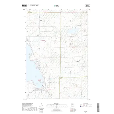
2019 Map of Isle
USGS Topo · Published 2019About this map
The southeastern shoreline of Mille Lacs Lake defines this landscape at the junction of Mille Lacs, Aitkin, and Kanabec counties. The city of Isle serves as the primary hub, where W Main St and Hennepin Ave S anchor a community deeply connected to the lake's eastern waters. This area is notable for its numerous burial grounds, including the Isle Cem, Sunset Cem, and the Sacred Heart Cem, suggesting a long-established residential and parish history. Northward, the map details the smaller settlements of Opstead and Redtop, the latter situated near Cedar Lake and the Redtop Cem. The terrain is characterized by intricate wetlands and watercourses like Cedar Cr and Malone Cr, while Malone Island and Pete Island sit just offshore from the city harbor. Local transportation is represented by the Isle Private Airport and a network of county roads that navigate the marshes and woodlands of the northern lake country.
Find a feature on this map
64 named features on this map. Tap any name to fly to it.
Don’t see what you’re looking for? This feature index may not catch every label — zoom into the map to look around manually.
Map Details
Editions of this 2019 Isle Map
This is the sole edition of this map. No revisions or reprints were ever made.
Other maps of this area

1916 · Wealthwood
USGS Topo · 1:62,500

1953 · Duluth
USGS Topo · 1:250,000

1958 · Duluth
USGS Topo · 1:250,000

1968 · Isle SW
USGS Topo · 1:24,000

1968 · Wahkon North
USGS Topo · 1:24,000

1968 · Isle
USGS Topo · 1:24,000

1968 · Warman
USGS Topo · 1:24,000
1968 · Wahkon South
USGS Topo · 1:24,000

1968 · Mc Grath
USGS Topo · 1:24,000

1969 · Thor SE
USGS Topo · 1:24,000