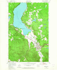
1950 Map of Issaquah
USGS Topo · Published 1964About this map
Issaquah serves as the focal point of this mid-century landscape, situated at the confluence of Issaquah Creek and the Northern Pacific railroad line. The map captures the area during a period of transition, where established industry like the State Fish Hatchery and Issaquah Airport coexist with remnants of earlier transport, such as an Old RR Grade and several stretches of Old Railroad Grade winding through the hills. To the north, the eastern shoreline of Sammamish Lake is dotted with small settlements like Inglewood and Monohan, while the interior terrain is defined by the high ground of Squak Mountain and Tiger Mountain. Notable local landmarks include Sammamish Camp at Greenwood Point and the County Gravel Pit near Grand Ridge, providing a detailed look at the rural and industrial makeup of King County before modern suburban expansion reshaped the valley floor.
Find a feature on this map
29 named features on this map. Tap any name to fly to it.
Don’t see what you’re looking for? This feature index may not catch every label — zoom into the map to look around manually.
Map Details
Editions of this 1950 Issaquah Map
4 editions found

Other maps of this area

1895 · Snohomish
USGS Topo · 1:125,000

1897 · Tacoma
USGS Topo · 1:125,000

1897 · Seattle
USGS Topo · 1:125,000

1900 · Tacoma
USGS Topo · 1:125,000

1913 · Cedar Lake
USGS Topo · 1:125,000

1921 · Sultan
USGS Topo · 1:125,000

1923 · Sultan
USGS Topo · 1:125,000

1949 · Maple Valley
USGS Topo · 1:24,000

1949 · Renton
USGS Topo · 1:24,000

1950 · Redmond
USGS Topo · 1:24,000