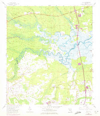
1958 Map of Italia
USGS Topo · Published 1972About this map
The Nassau River and its intricate network of tributaries, including Thomas Creek and Plummer Creek, dominate this coastal Florida landscape at the border of Nassau and Duval counties. The area is characterized by vast wetland systems like Tom Mann Swamp and Boggy Creek, where the transition from water to land is marked by local landmarks such as Smiths Point and Halfmoon Island. Settlement is sparse, anchored by the community of Italia and the nearby Hero along the Buccaneer Trail. To the south, the emergence of modern infrastructure is evident near the Jacksonville International Airport. Cultural life in these rural reaches centers on sites like Harpers Chapel, Barford Ch, and Ogden Cem. The presence of the Jacksonville Penal Farm and the Seaboard Coast Line railroad reflects the region's mid-century correctional and transportation logistics before the full expansion of the Jacksonville metropolitan area.
Find a feature on this map
26 named features on this map. Tap any name to fly to it.
Don’t see what you’re looking for? This feature index may not catch every label — zoom into the map to look around manually.
Map Details
Editions of this 1958 Italia Map
4 editions found
Other maps of this area

1917 · Cambon
USGS Topo · 1:62,500

1917 · Hilliard
USGS Topo · 1:62,500

1918 · St Marys
USGS Topo · 1:62,500

1918 · Cambon
USGS Topo · 1:62,500

1918 · Jacksonville
USGS Topo · 1:62,500

1919 · St Marys
USGS Topo · 1:62,500

1919 · Hilliard
USGS Topo · 1:62,500

1948 · Jacksonville
USGS Topo · 1:250,000

1948 · Eastport
USGS Topo · 1:24,000

1950 · Trout River
USGS Topo · 1:24,000