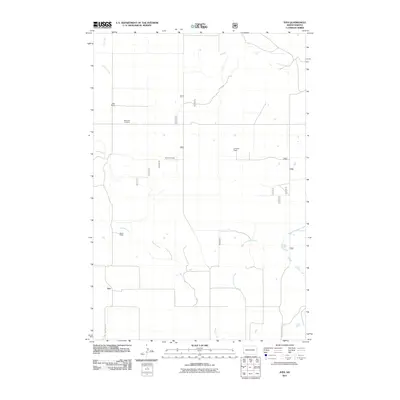
2011 Map of Ives
USGS Topo · Published 2011About this map
Saint Paul Cemetery sits as a quiet landmark within this expansive North Dakota landscape, situated near the western edge of the quadrangle. The settlement of Ives and several family-run operations, including the Oldis Ranch, Swenson Ranch, and Weisz Ranch, reflect the area's deep-rooted ranching tradition. The terrain is defined by a network of drainage systems, most notably Bacon Creek, which meanders through the central portion of the map, and the West Fork Deep Creek to the southeast. Transportation throughout this part of Bowman County is facilitated by local routes such as Fort Dilts Rd and County Hwy 4424. This record of the land captures the sparse but organized settlement pattern of the High Plains, where vast tracts of land are tied to specific homesteads and family names near the headwaters of Indian Creek and Cash Creek.
Find a feature on this map
24 named features on this map. Tap any name to fly to it.
Don’t see what you’re looking for? This feature index may not catch every label — zoom into the map to look around manually.
Map Details
Editions of this 2011 Ives Map
This is the sole edition of this map. No revisions or reprints were ever made.
Other maps of this area

1953 · Dickinson
USGS Topo · 1:250,000

1957 · Dickinson
USGS Topo · 1:250,000

1973 · Griffin
USGS Topo · 1:24,000

1973 · Cedar Hills
USGS Topo · 1:24,000

1973 · Rhame
USGS Topo · 1:24,000

1979 · Ives
USGS Topo · 1:24,000

1980 · Boyce Creek West
USGS Topo · 1:24,000

1981 · Bowman
USGS Topo · 1:100,000
1997 · Boyce Creek West
USGS Topo · 1:24,000
1997 · Marmarth SE
USGS Topo · 1:24,000