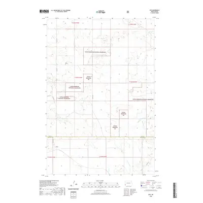
2020 Map of Ives
USGS Topo · Published 2020About this map
Saint Paul Cem sits as a lonely landmark within the wide open expanses of southwestern North Dakota, specifically where the borders of Slope and Bowman Counties meet. This 2020 map documents the modern landscape of the Little Missouri National Grassland, an area characterized by its sparse settlement and seasonal watercourses like Indian Cr and W Fork Deep Cr. The settlement of Ives is located in the southern portion of the quadrangle along the historical route of Fort Dilts Rd. Much of the terrain is defined by the Public Land Survey System grid, which segments the territory into townships such as t133n r104w, while the drainage of Bacon Cr and Cash Cr dictates the few variations in the local geography.
Find a feature on this map
21 named features on this map. Tap any name to fly to it.
Don’t see what you’re looking for? This feature index may not catch every label — zoom into the map to look around manually.
Map Details
Editions of this 2020 Ives Map
This is the sole edition of this map. No revisions or reprints were ever made.
Other maps of this area

1953 · Dickinson
USGS Topo · 1:250,000

1957 · Dickinson
USGS Topo · 1:250,000

1973 · Griffin
USGS Topo · 1:24,000

1973 · Cedar Hills
USGS Topo · 1:24,000

1973 · Rhame
USGS Topo · 1:24,000

1979 · Ives
USGS Topo · 1:24,000

1980 · Boyce Creek West
USGS Topo · 1:24,000

1981 · Bowman
USGS Topo · 1:100,000
1997 · Boyce Creek West
USGS Topo · 1:24,000
1997 · Marmarth SE
USGS Topo · 1:24,000