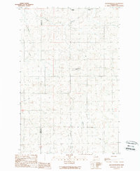
1989 Map of Jack Woods Butte
USGS Topo · Published 1989About this map
Jack Woods Butte rises as a prominent landmark in this upland landscape where the Grant and Lincoln County border meets. The map shows a region defined by its dry drainage systems, including Klobuschar Draw and Devils Creek, which carve through the plateau. Local agricultural and social hubs are evident at the Grand Coulee Grange and the rail-related Bagdad Junction in the north. This 1989 provisional edition captures the rural character of the area, punctuated by essential infrastructure like the Radio Tower & Lookout on the butte. Genealogists and local historians can find family-named sites such as Lafollette Cem and Childers Draw, reflecting the early settlement patterns of this Washington interior before modern development obscured these old homestead markers.
Find a feature on this map
9 named features on this map. Tap any name to fly to it.
Don’t see what you’re looking for? This feature index may not catch every label — zoom into the map to look around manually.
Map Details
Editions of this 1989 Jack Woods Butte Map
This is the sole edition of this map. No revisions or reprints were ever made.
Other maps of this area

1948 · Grand Coulee Dam
USGS Topo · 1:62,500

1950 · Grand Coulee Dam
USGS Topo · 1:62,500

1953 · Ritzville
USGS Topo · 1:250,000

1959 · Ritzville
USGS Topo · 1:250,000

1965 · Ritzville
USGS Topo · 1:250,000

1968 · Hartline
USGS Topo · 1:24,000

1968 · Steamboat Rock SE
USGS Topo · 1:24,000
1968 · Electric City
USGS Topo · 1:24,000

1969 · Almira
USGS Topo · 1:24,000

1969 · Govan
USGS Topo · 1:24,000