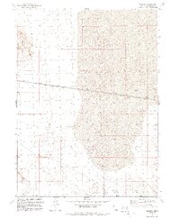
1991 Map of Jackson
USGS Topo · Published 1992About this map
The Lucin Cutoff railroad alignment strikes a sharp horizontal line across the desolate salt flats of northwestern Utah in the early 1990s. This specific stretch of the historic rail corridor includes the remote siding or station point of Jackson, positioned amidst an expansive area of Mud that characterizes the Great Salt Lake Desert. The terrain is punctuated by isolated elevations such as Pigeon Mountain in the northwest and the Little Pigeon Mts to the south. Small water sources like the Spring found near the southern margin offer rare relief in an otherwise arid and alkaline landscape. The presence of the Lucin Cutoff Private road alongside the tracks highlights the industrial infrastructure required to maintain this vital transportation link through the desert floor.
Find a feature on this map
7 named features on this map. Tap any name to fly to it.
Don’t see what you’re looking for? This feature index may not catch every label — zoom into the map to look around manually.
Map Details
Editions of this 1991 Jackson Map
This is the sole edition of this map. No revisions or reprints were ever made.
Other maps of this area

1954 · Brigham City
USGS Topo · 1:250,000

1958 · Brigham City
USGS Topo · 1:250,000

1962 · Brigham City
USGS Topo · 1:250,000

1967 · Pigeon Mountain
USGS Topo · 1:24,000

1967 · Lucin NE
USGS Topo · 1:24,000

1967 · Lemay Island
USGS Topo · 1:24,000

1983 · Jackson
USGS Topo · 1:24,000

1983 · Bovine SE
USGS Topo · 1:24,000

1983 · Terrace Mountain West
USGS Topo · 1:24,000

1983 · Lucin 4 NE
USGS Topo · 1:24,000