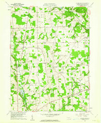
1960 Map of Jackson Center
USGS Topo · Published 1961About this map
Jackson Center and the surrounding townships of Lake and Jackson reveal a landscape defined by 1960s industry and rural tradition. The rail infrastructure of the New York Central RR and Bessemer and Lake Erie cuts through the terrain, connecting small settlements like Stoneboro and Fairview to the broader regional economy. The presence of several Strip Mines in the southeastern quadrant, particularly near Nesbit Corners, highlights the area's extraction history, while the numerous burial grounds such as Centenary Cem and Zahniser Cem offer significant touchpoints for genealogical research.
Find a feature on this map
40 named features on this map. Tap any name to fly to it.
Don’t see what you’re looking for? This feature index may not catch every label — zoom into the map to look around manually.
Map Details
Editions of this 1960 Jackson Center Map
3 editions found
Other maps of this area

1905 · Neshannock
USGS Topo · 1:62,500

1907 · Neshannock
USGS Topo · 1:62,500

1908 · Shenango
USGS Topo · 1:62,500

1911 · Stoneboro
USGS Topo · 1:62,500

1913 · Stoneboro
USGS Topo · 1:62,500

1913 · Mercer
USGS Topo · 1:62,500

1939 · Mercer
USGS Topo · 1:62,500

1943 · Mercer
USGS Topo · 1:62,500

1943 · Stoneboro
USGS Topo · 1:62,500

1950 · Cleveland
USGS Topo · 1:250,000
Featured Places
- Fairview Township, PA
- New Vernon Township, PA
- Jackson Center, PA
- Coolspring Township, PA
- Perry Township, PA