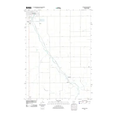
2010 Map of Jackson
USGS Topo · Published 2010About this map
The Des Moines River carves a winding path through this south-central Minnesota landscape, anchored by the seat of Jackson County. In the northern reaches of the sheet, the river is harnessed by the Jackson Dam, which stands near the Jackson Post Office and the primary town center. The settlement patterns here reveal a strong connection to local genealogy, evidenced by the numerous burial grounds including Riverside Cemetery, Sunset Cemetery, and Hillside Cemetery.
Find a feature on this map
32 named features on this map. Tap any name to fly to it.
Don’t see what you’re looking for? This feature index may not catch every label — zoom into the map to look around manually.
Map Details
Editions of this 2010 Jackson Map
This is the sole edition of this map. No revisions or reprints were ever made.
Other maps of this area

1954 · Fairmont
USGS Topo · 1:250,000

1958 · Fairmont
USGS Topo · 1:250,000

1970 · Jackson NW
USGS Topo · 1:24,000

1970 · Lakefield NE
USGS Topo · 1:24,000

1970 · Jackson
USGS Topo · 1:24,000

1970 · Lakefield SE
USGS Topo · 1:24,000

1970 · Dunnell
USGS Topo · 1:24,000

1970 · Spirit Lake
USGS Topo · 1:24,000
1970 · Alpha
USGS Topo · 1:24,000

1972 · Estherville
USGS Topo · 1:24,000
Featured Places
- Jackson, MN
- Petersburg, MN
- West Ridge Village Mobile Home Park, Jackson
- Dickinson County, IA
- Emmet County, IA