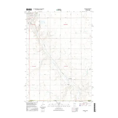
2016 Map of Jackson
USGS Topo · Published 2016About this map
The Des Moines River winds through this landscape on the border of Minnesota and Iowa, anchoring the city of Jackson at the northern edge of the map. This 2016 survey illustrates the extensive water management systems of the region, including the Des Moines River Reservoir and engineered waterways like Judicial Ditch Number Fifty-six and Judicial Ditch Number Eleven. These features reflect the long-standing agricultural importance of the area, where natural drainages like Stony Brook and Fourmile Cr have been supplemented by straight-line ditching to manage the flat prairie terrain.
Find a feature on this map
53 named features on this map. Tap any name to fly to it.
Don’t see what you’re looking for? This feature index may not catch every label — zoom into the map to look around manually.
Map Details
Editions of this 2016 Jackson Map
This is the sole edition of this map. No revisions or reprints were ever made.
Other maps of this area

1954 · Fairmont
USGS Topo · 1:250,000

1958 · Fairmont
USGS Topo · 1:250,000

1970 · Jackson NW
USGS Topo · 1:24,000

1970 · Lakefield NE
USGS Topo · 1:24,000

1970 · Jackson
USGS Topo · 1:24,000

1970 · Lakefield SE
USGS Topo · 1:24,000

1970 · Dunnell
USGS Topo · 1:24,000

1970 · Spirit Lake
USGS Topo · 1:24,000
1970 · Alpha
USGS Topo · 1:24,000

1972 · Estherville
USGS Topo · 1:24,000
Featured Places
- Jackson, MN
- Petersburg, MN
- West Ridge Village Mobile Home Park, Jackson
- Dickinson County, IA
- Emmet County, IA