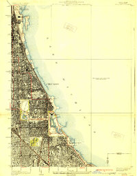
1929 Map of Jackson Park
USGS Topo · Published 1929About this map
Lake Michigan's shoreline defines the eastern edge of this dense urban grid, showing the city's lakefront architecture and public spaces in the late 1920s. Centered on the South Side, the map details the expansive grounds of Jackson Park, where the West Lagoon and East Lagoon meet the Yacht Harbor. A notable local history landmark, the Old Field Museum stands as a remnant of the 1893 World's Fair, while further north, the recently completed Soldiers Field and Field Museum dominate Grant Park. The layout of the Midway Plaisance creates a formal green corridor connecting to Washington Park, illustrating the intentional design of the city's park system. Industrial and transit arteries like the Illinois Central railroad cut through the residential blocks, providing context for the neighborhood's growth near Oakwoods Cemetery and the South Shore Country Club.
Find a feature on this map
50 named features on this map. Tap any name to fly to it.
Don’t see what you’re looking for? This feature index may not catch every label — zoom into the map to look around manually.
Map Details
Editions of this 1929 Jackson Park Map
3 editions found
Other maps of this area

1889 · Chicago
USGS Topo · 1:62,500

1891 · Chicago
USGS Topo · 1:62,500

1892 · Calumet
USGS Topo · 1:62,500

1893 · Calumet
USGS Topo · 1:62,500

1900 · Chicago
USGS Topo · 1:62,500

1900 · Toleston
USGS Topo · 1:62,500

1900 · Calumet
USGS Topo · 1:62,500

1901 · Calumet
USGS Topo · 1:62,500

1901 · Chicago
USGS Topo · 1:62,500

1929 · Calumet Lake
USGS Topo · 1:24,000