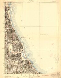
1929 Map of Jackson Park
USGS Topo · Published 1929About this map
Lake Michigan defines the eastern edge of this 1920s urban landscape, where the dense grid of Chicago meets a series of sprawling lakeside commons. The lakefront exhibits significant civil engineering, from the Chicago Harbor down to the South Shore Country Club. Inland, the city's commitment to public spaces is evident in the grand connection between Washington Park and Jackson Park via the Midway Plaisance.
Find a feature on this map
36 named features on this map. Tap any name to fly to it.
Don’t see what you’re looking for? This feature index may not catch every label — zoom into the map to look around manually.
Map Details
Editions of this 1929 Jackson Park Map
3 editions found
Other maps of this area

1889 · Chicago
USGS Topo · 1:62,500

1891 · Chicago
USGS Topo · 1:62,500

1892 · Calumet
USGS Topo · 1:62,500

1893 · Calumet
USGS Topo · 1:62,500

1900 · Chicago
USGS Topo · 1:62,500

1900 · Toleston
USGS Topo · 1:62,500

1900 · Calumet
USGS Topo · 1:62,500

1901 · Calumet
USGS Topo · 1:62,500

1901 · Chicago
USGS Topo · 1:62,500

1929 · Calumet Lake
USGS Topo · 1:24,000