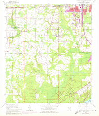
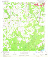
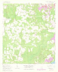
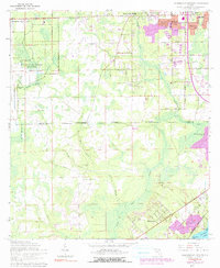
1964 Map of Jacksonville Heights
USGS Topo · Published 1972About this map
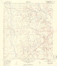
U S Naval Air Station (Cecil Field) occupies much of the northwestern portion of this landscape, marking a significant military presence during this era of Florida's growth. The boundary between Duval Co and Clay Co bisects the terrain, where suburban expansion begins to meet the wooded drainages of the Ortega River and Black Creek. New residential developments like Enchanted Park and North Meadowbrook Terrace appear alongside established landmarks such as the Jacksonville Heights Ch and the Federal Hill Cem. Industrial activity is evident in several Sandpits scattered across the quadrangle, while the Seaboard Coast Line railroad provides a major transportation corridor. To the southeast, the terrain descends toward the water at Sugarhouse Cove on Doctors Lake, illustrating the transition from military airfield and piney woods to waterfront settlement.
Find a feature on this map
44 named features on this map. Tap any name to fly to it.
Don’t see what you’re looking for? This feature index may not catch every label — zoom into the map to look around manually.
Map Details
Editions of this 1964 Jacksonville Heights Map
4 editions found
Other maps of this area

1917 · Orange Park
USGS Topo · 1:62,500

1917 · Cambon
USGS Topo · 1:62,500

1918 · Middleburg
USGS Topo · 1:62,500

1918 · Cambon
USGS Topo · 1:62,500

1918 · Jacksonville
USGS Topo · 1:62,500

1918 · Orange Park
USGS Topo · 1:62,500

1941 · Middleburg
USGS Topo · 1:62,500

1948 · Jacksonville
USGS Topo · 1:250,000
1949 · Middleburg SW
USGS Topo · 1:24,000

1949 · Fiftone
USGS Topo · 1:24,000
Featured Places
- Jacksonville, FL
- Oak Hill, Jacksonville
- Westwood, Jacksonville
- Oak Hill Park, Jacksonville
- Ridgewood, FL