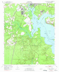
1952 Map of Jacksonville South
USGS Topo · Published 1975About this map
Camp Lejeune Military Reservation dominates the landscape of this 1950s survey, illustrating the extensive coastal defense and training infrastructure established in Onslow County. The map details the transition from rural settlements and coastal forests to a structured military environment, featuring the Peters Point Field Glider Base and various tactical landmarks such as Tulagi and Solomons. The Atlantic Coast Line railroad runs parallel to the coastline, connecting the community of Verona with the growing hub of Jacksonville. Along the shores of the New River and Morgan Bay, the map reveals a mix of tidal flats and residential development, including Paradise Isle and White Oak. Local institutions like Georgetown High Sch and Bay Ch are documented alongside geographical features like Stump Sound, providing a record of the area's mid-century social and physical geography.
Find a feature on this map
52 named features on this map. Tap any name to fly to it.
Don’t see what you’re looking for? This feature index may not catch every label — zoom into the map to look around manually.
Map Details
Editions of this 1952 Jacksonville South Map
4 editions found
Other maps of this area

1943 · Jacksonville
USGS Topo · 1:62,500

1948 · Maple Hill
USGS Topo · 1:62,500

1948 · New River
USGS Topo · 1:62,500

1948 · Richlands
USGS Topo · 1:62,500

1952 · Camp Lejeune
USGS Topo · 1:24,000

1952 · Jacksonville South
USGS Topo · 1:24,000

1952 · New River Inlet
USGS Topo · 1:24,000

1952 · Sneads Ferry
USGS Topo · 1:24,000

1953 · Beaufort
USGS Topo · 1:250,000

1954 · Beaufort
USGS Topo · 1:250,000