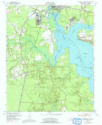
1952 Map of Jacksonville South
USGS Topo · Published 1992About this map
Camp Lejeune Military Reservation dominates this coastal landscape, reflecting the rapid expansion of military infrastructure along the North Carolina shoreline during the mid-20th century. The map highlights the strategic integration of naval and aviation facilities, notably the Peters Point Field Glider Base situated on the western bank of the New River. This waterway, along with the Northeast New River and Wilson Bay, forms a complex estuarine network that served both civilian commerce and military logistics. The Atlantic Coast Line railroad runs parallel to established routes like Hawsrum Road, connecting rural settlements such as Verona and Paradise. Local history is preserved in the location of the Georgetown High Sch and Bay Ch, alongside family-named points like Hadnot Pt and Solomons Pt, marking a time before significant modern development altered the tidal reaches of Stump Sound.
Find a feature on this map
43 named features on this map. Tap any name to fly to it.
Don’t see what you’re looking for? This feature index may not catch every label — zoom into the map to look around manually.
Map Details
Editions of this 1952 Jacksonville South Map
4 editions found
Other maps of this area

1943 · Jacksonville
USGS Topo · 1:62,500

1948 · Maple Hill
USGS Topo · 1:62,500

1948 · New River
USGS Topo · 1:62,500

1948 · Richlands
USGS Topo · 1:62,500

1952 · Camp Lejeune
USGS Topo · 1:24,000

1952 · Jacksonville South
USGS Topo · 1:24,000

1952 · New River Inlet
USGS Topo · 1:24,000

1952 · Sneads Ferry
USGS Topo · 1:24,000

1953 · Beaufort
USGS Topo · 1:250,000

1954 · Beaufort
USGS Topo · 1:250,000