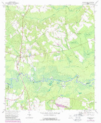
1972 Map of Jacksonville
USGS Topo · Published 1988About this map
Jacksonville sits at a critical bend where the Ocmulgee River meets the crossing point of the Jacksonville Ferry Bridge. This 1970s landscape, updated in the late 1980s, reveals a rural Georgia community defined by its proximity to the river and a network of creeks like Alligator Creek and Lumpkin Branch. The settlement pattern is deeply historical, anchored by numerous small churches and family burial grounds that reflect generations of local residency. Landmarks such as St Pauls Ch, Graham Ch, and Salem Ch serve as neighborhood anchors across the terrain.
Find a feature on this map
43 named features on this map. Tap any name to fly to it.
Don’t see what you’re looking for? This feature index may not catch every label — zoom into the map to look around manually.
Map Details
Editions of this 1972 Jacksonville Map
2 editions found
Other maps of this area

1953 · Waycross
USGS Topo · 1:250,000

1958 · Waycross
USGS Topo · 1:250,000

1971 · Jacksonville NE
USGS Topo · 1:24,000

1971 · Snipesville
USGS Topo · 1:24,000

1971 · Broxton NE
USGS Topo · 1:24,000

1972 · Cooks Still
USGS Topo · 1:24,000

1972 · Broxton North
USGS Topo · 1:24,000

1972 · Jacksonville
USGS Topo · 1:24,000

1972 · China Hill
USGS Topo · 1:24,000
1972 · Workmore
USGS Topo · 1:24,000