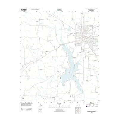
2013 Map of Jacksonville West
USGS Topo · Published 2013About this map
Lake Jacksonville dominates the central landscape of this western Cherokee County region, its irregular shoreline creating numerous points such as Oak Point and Piney Point. The area is characterized by a network of established rural settlements and family landmarks, including Mountain Heaven and Church Hill. Local genealogy is particularly well-represented through numerous burial sites like Grimes Cem, Resthaven Cem, and Ragsdale Cem. The terrain rises toward the south and west at Luker Mtn and Casey Mtn, while the community of Ironton and the gathering place at Earles Chapel mark the western reaches. This survey documents the transition from the structured street grid of western Jacksonville into the surrounding countryside, where small settlements like New Hope and Pine Grove are connected by a dense system of county roads and creek drainages including Sixmile Cr and Gum Cr.
Find a feature on this map
164 named features on this map. Tap any name to fly to it.
Don’t see what you’re looking for? This feature index may not catch every label — zoom into the map to look around manually.
Map Details
Editions of this 2013 Jacksonville West Map
This is the sole edition of this map. No revisions or reprints were ever made.
Other maps of this area

1937 · Troupe
USGS Topo · 1:48,000

1943 · Troup
USGS Topo · 1:62,500

1943 · Rusk
USGS Topo · 1:62,500

1945 · Rusk
USGS Topo · 1:62,500

1946 · Bullard
USGS Topo · 1:62,500

1948 · Bullard
USGS Topo · 1:62,500

1951 · Jacksonville
USGS Topo · 1:62,500

1953 · Palestine
USGS Topo · 1:250,000

1956 · Tyler
USGS Topo · 1:250,000

1957 · Palestine
USGS Topo · 1:250,000