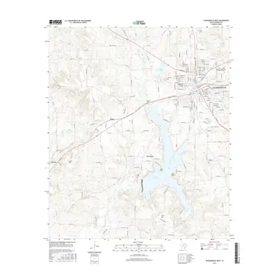
2016 Map of Jacksonville West
USGS Topo · Published 2016About this map
Jacksonville anchors the eastern edge of this East Texas survey, revealing a landscape defined by higher learning and significant water resources. The city’s academic character is established by the Jacksonville College-Main Campus, Lon Morris Coll, and the Baptist Missionary Association Theological Seminary. To the west, the topography transitions from the urban grid into the rolling terrain of the Piney Woods, dominated by the sprawling reaches of Lake Jacksonville. This reservoir, featuring points like Oak Point and Piney Point, serves as a central geographical marker for the surrounding rural communities. Smaller settlements such as New Hope, Hume, and Ironton are connected by a network of county roads and farm-to-market routes like FM 747. Notable local landmarks including Luker Mtn and Casey Mtn rise above the creek drainages of Gum Cr and Sixmile Cr, while numerous family and community burial grounds like Grimes Cem and Miles Cem provide essential data for genealogical research.
Find a feature on this map
176 named features on this map. Tap any name to fly to it.
Don’t see what you’re looking for? This feature index may not catch every label — zoom into the map to look around manually.
Map Details
Editions of this 2016 Jacksonville West Map
This is the sole edition of this map. No revisions or reprints were ever made.
Other maps of this area
1937 · Troupe
USGS Topo · 1:48,000
1943 · Troup
USGS Topo · 1:62,500
1943 · Rusk
USGS Topo · 1:62,500
1945 · Rusk
USGS Topo · 1:62,500
1946 · Bullard
USGS Topo · 1:62,500
1948 · Bullard
USGS Topo · 1:62,500
1951 · Jacksonville
USGS Topo · 1:62,500

1953 · Palestine
USGS Topo · 1:250,000

1956 · Tyler
USGS Topo · 1:250,000

1957 · Palestine
USGS Topo · 1:250,000