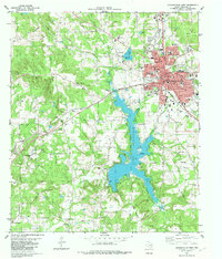
1982 Map of Jacksonville West
USGS Topo · Published 1982About this map
The expanding town of Jacksonville serves as the focal point of this East Texas survey, where the convergence of the Southern Pacific and Missouri Pacific railroads historically shaped the local economy. The urban grid is dense with educational and social landmarks, including Jacksonville College, Lon Morris College, and the Rodeo Ground. To the south, the sprawling waters of Lake Jacksonville dominate the landscape, its jagged shoreline featuring Oak Point and Piney Point near several lakeside campgrounds.
Find a feature on this map
56 named features on this map. Tap any name to fly to it.
Don’t see what you’re looking for? This feature index may not catch every label — zoom into the map to look around manually.
Map Details
Editions of this 1982 Jacksonville West Map
This is the sole edition of this map. No revisions or reprints were ever made.
Other maps of this area

1937 · Troupe
USGS Topo · 1:48,000

1943 · Troup
USGS Topo · 1:62,500

1943 · Rusk
USGS Topo · 1:62,500

1945 · Rusk
USGS Topo · 1:62,500

1946 · Bullard
USGS Topo · 1:62,500

1948 · Bullard
USGS Topo · 1:62,500

1951 · Jacksonville
USGS Topo · 1:62,500

1953 · Palestine
USGS Topo · 1:250,000

1956 · Tyler
USGS Topo · 1:250,000

1957 · Palestine
USGS Topo · 1:250,000