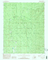
1988 Map of Jacob Lake
USGS Topo · Published 1988About this map
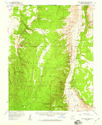
Jacob Lake serves as the central hub of this late-1980s landscape, situated at the junction of Highway 89 and Highway 67. The surrounding area is defined by its placement within the Kaibab National Forest and the Grand Canyon National Game Preserve. A Ranger Station and Jacob Reservoir indicate the administrative and practical management of this high-elevation plateau. The terrain is marked by a complex series of drainages, including Le Fevre Canyon and Orderville Canyon, which flank the prominent Cooper Ridge. The presence of several distinct depressions and water catchments, such as Billy Sink, Jolly Sink, and Buffalo Hill Tank, illustrates the natural and man-made water management systems necessary in this arid environment. Further south, the map reveals the convergence of the West Fork and East Fork near Fracas Lake.
Find a feature on this map
34 named features on this map. Tap any name to fly to it.
Don’t see what you’re looking for? This feature index may not catch every label — zoom into the map to look around manually.
Map Details
Editions of this 1988 Jacob Lake Map
2 editions found
Other maps of this area

1886 · Kaibab
USGS Topo · 1:250,000

1936 · Jacobs Lake
USGS Topo · 1:48,000

1940 · Jacob Lake
USGS Topo · 1:62,500

1953 · Jacobs Lake
USGS Topo · 1:62,500

1953 · Grand Canyon
USGS Topo · 1:250,000
1954 · House Rock Spring SE
USGS Topo · 1:24,000

1957 · Grand Canyon
USGS Topo · 1:250,000

1957 · Shinarump SE
USGS Topo · 1:24,000
1957 · House Rock Spring SW
USGS Topo · 1:24,000
1957 · House Rock Spring
USGS Topo · 1:62,500