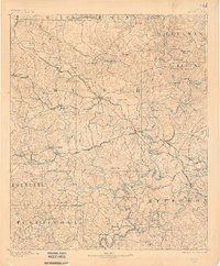
1893 Map of Jasper
USGS Topo · Published 1899About this map
Jasper serves as the central hub for this late nineteenth-century portrait of Alabama’s coal country, where the nascent mining industry and a complex network of river crossings define the landscape. The geography is dictated by the deeply carved paths of the Sipsey Fork and Mulberry Fork, which converge at the Black Warrior River. Before the era of modern bridges, local commerce relied heavily on family-named transit points like Snow Fy. and Goodwin Fd..
Find a feature on this map
146 named features on this map. Tap any name to fly to it.
Don’t see what you’re looking for? This feature index may not catch every label — zoom into the map to look around manually.
Map Details
Editions of this 1893 Jasper Map
5 editions found
Other maps of this area

1888 · Cullman
USGS Topo · 1:125,000

1889 · Birmingham
USGS Topo · 1:125,000

1890 · Bessemer
USGS Topo · 1:125,000

1892 · Cullman
USGS Topo · 1:125,000

1892 · Birmingham
USGS Topo · 1:125,000

1892 · Bessemer
USGS Topo · 1:125,000

1893 · Jasper
USGS Topo · 1:125,000

1895 · Birmingham
USGS Topo · 1:125,000

1899 · Brookwood
USGS Topo · 1:125,000

1904 · Birmingham Coal District
USGS Topo · 1:62,500