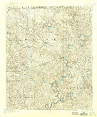
1893 Map of Jasper
USGS Topo · Published 1942About this map
Jasper serves as the central hub of this 1891 survey, situated at the junction of critical transit routes that defined the Alabama coalfields during the late nineteenth century. The landscape is characterized by a dense network of watercourse crossings and early industrial sites, including the Gamble Mines and Corona Mines, which signify the region's burgeoning extraction economy. Along the winding Warrior River and Sipsey Fork, numerous family-named river crossings like Sanderson Ferry and Reed Ferry illustrate how local commerce functioned before the widespread construction of permanent bridges.
Find a feature on this map
87 named features on this map. Tap any name to fly to it.
Don’t see what you’re looking for? This feature index may not catch every label — zoom into the map to look around manually.
Map Details
Editions of this 1893 Jasper Map
5 editions found
Other maps of this area

1888 · Cullman
USGS Topo · 1:125,000

1889 · Birmingham
USGS Topo · 1:125,000

1890 · Bessemer
USGS Topo · 1:125,000

1892 · Cullman
USGS Topo · 1:125,000

1892 · Birmingham
USGS Topo · 1:125,000

1892 · Bessemer
USGS Topo · 1:125,000

1893 · Jasper
USGS Topo · 1:125,000

1895 · Birmingham
USGS Topo · 1:125,000

1899 · Brookwood
USGS Topo · 1:125,000

1904 · Birmingham Coal District
USGS Topo · 1:62,500