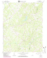
1966 Map of Java
USGS Topo · Published 1984About this map
Java and the surrounding rural hamlets of southern Virginia are depicted in this mid-century landscape just before suburban transitions reached the area. The terrain is defined by the winding course of Banister River and the significant drainage of Elkhorn Creek, which feeds into the central Elkhorn Lake. This region shows a traditional Piedmont settlement pattern of small crossroads communities and family-named landmarks such as Chaneys Store and Henrys Mill. Local genealogy is well-represented through numerous small churches and burial sites, including Womacks Chapel, St Pauls Ch, and Providence Ch. The presence of the Pittsylvania Co Halifax Co line cutting through the eastern portion of the sheet provides a clear spatial reference for those researching ancestors in these two historically connected counties. While many of these locations were established around early milling and merchant points like Lucks and Ebenezer, the map also records modern infrastructure such as a major Pipeline cutting across the northern ridges.
Find a feature on this map
27 named features on this map. Tap any name to fly to it.
Don’t see what you’re looking for? This feature index may not catch every label — zoom into the map to look around manually.
Map Details
Editions of this 1966 Java Map
3 editions found
Other maps of this area

1921 · Chatham
USGS Topo · 1:48,000

1923 · Danville
USGS Topo · 1:48,000

1923 · Chatham
USGS Topo · 1:62,500

1925 · Danville
USGS Topo · 1:62,500

1952 · Milton
USGS Topo · 1:62,500

1953 · Greensboro
USGS Topo · 1:250,000

1954 · Greensboro
USGS Topo · 1:250,000

1954 · Riceville
USGS Topo · 1:62,500

1956 · Milton
USGS Topo · 1:62,500

1962 · Greensboro
USGS Topo · 1:250,000