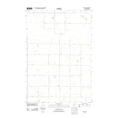
2012 Map of Java SE
USGS Topo · Published 2012About this map
The agricultural plains of Walworth County are defined by a rhythmic grid of rural avenues and section-line roads in this 2012 survey. Sparse water features like Hiddenwood Cr and Swan Lake Cr cut through the prairie, providing the primary relief in an otherwise strictly organized landscape of rectangular fields. The map reveals a deeply rooted community structure, evidenced by the distribution of country burial grounds that served different denominational groups. These include the Seventh-Day Adventist Cem in the north and the Baptist Cem near the eastern border. Near the southern edge, the Java East Cem and Saint Paul Cem sit among the fields, marking the legacy of the area's early families and congregations. The topography is predominantly open, with small scattered wetlands punctuating the spaces between the long corridors of 315th Ave and 321st Ave.
Find a feature on this map
22 named features on this map. Tap any name to fly to it.
Don’t see what you’re looking for? This feature index may not catch every label — zoom into the map to look around manually.
Map Details
Editions of this 2012 Java SE Map
This is the sole edition of this map. No revisions or reprints were ever made.
Other maps of this area

1954 · Aberdeen
USGS Topo · 1:250,000

1956 · Aberdeen
USGS Topo · 1:250,000

1974 · Spring Lake
USGS Topo · 1:24,000
1974 · Lowry NW
USGS Topo · 1:24,000

1974 · Bowdle
USGS Topo · 1:24,000

1978 · Salt Lake
USGS Topo · 1:24,000

1978 · Bowdle-Hosmer Lake
USGS Topo · 1:24,000

1978 · Java SE
USGS Topo · 1:24,000
1978 · Java
USGS Topo · 1:24,000

1978 · Flat Lake
USGS Topo · 1:24,000