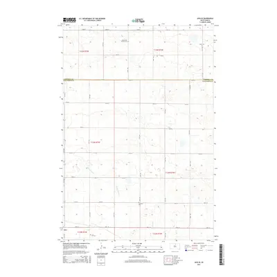
2015 Map of Java SE
USGS Topo · Published 2015About this map
Java serves as the focal point of this rural prairie landscape near the junction of Campbell and Walworth counties. The town is flanked by the Java East Cem and Saint Paul Cem, while the surrounding sections maintain a strictly gridded agricultural character. Local heritage is deeply rooted in the several denominational burial grounds dispersed across the plains, including the Baptist Cem and the Seventh-Day Adventist Cem, reflecting the early settlement patterns of this region. The terrain is defined by low-lying depressions and the meandering paths of Hiddenwood Cr and Swan Lake Cr, which cut through the landscape north of 130th ST. This topography highlights the transition between the rolling uplands and the drainage basins that define the local hydrology.
Find a feature on this map
30 named features on this map. Tap any name to fly to it.
Don’t see what you’re looking for? This feature index may not catch every label — zoom into the map to look around manually.
Map Details
Editions of this 2015 Java SE Map
This is the sole edition of this map. No revisions or reprints were ever made.
Other maps of this area

1954 · Aberdeen
USGS Topo · 1:250,000

1956 · Aberdeen
USGS Topo · 1:250,000

1974 · Spring Lake
USGS Topo · 1:24,000
1974 · Lowry NW
USGS Topo · 1:24,000

1974 · Bowdle
USGS Topo · 1:24,000

1978 · Salt Lake
USGS Topo · 1:24,000

1978 · Bowdle-Hosmer Lake
USGS Topo · 1:24,000

1978 · Java SE
USGS Topo · 1:24,000
1978 · Java
USGS Topo · 1:24,000

1978 · Flat Lake
USGS Topo · 1:24,000