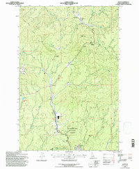
1994 Map of Jaype
USGS Topo · Published 1997About this map
Townsite Four and the Wood Products Plant at Jaype anchor this timber-focused corridor of the Clearwater National Forest during the mid-1990s. The landscape is defined by the industry and infrastructure of northern Idaho, featuring the Old Railroad Grade that winds alongside Reeds Creek and its many forks. Small settlements and loading points like Hollywood, Revling, and Cardiff Spur trace the path of resource extraction and transport.
Find a feature on this map
49 named features on this map. Tap any name to fly to it.
Don’t see what you’re looking for? This feature index may not catch every label — zoom into the map to look around manually.
Map Details
Editions of this 1994 Jaype Map
This is the sole edition of this map. No revisions or reprints were ever made.
Other maps of this area

1923 · Washington Creek
USGS Topo · 1:125,000

1924 · Weippe
USGS Topo · 1:125,000

1938 · Headquarters
USGS Topo · 1:48,000

1944 · Headquarters
USGS Topo · 1:62,500

1956 · Hamilton
USGS Topo · 1:250,000

1959 · Hamilton
USGS Topo · 1:250,000

1960 · Hamilton
USGS Topo · 1:250,000

1964 · Hamilton
USGS Topo · 1:250,000

1965 · French Mountain
USGS Topo · 1:24,000

1966 · Pierce
USGS Topo · 1:24,000