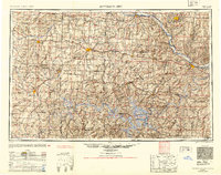
1954 Map of Jefferson City
USGS Topo · Published 1954About this map
Missouri River and Lake of the Ozarks dominate the drainage and topography of this mid-century Missouri interior. The state capital, Jefferson City, serves as a primary hub for the region, while the sprawling Lake of the Ozarks to the south shows its complex shoreline and established recreation areas like Ha Ha Tonka State Park. Further west, the map details the agricultural and rail-oriented centers of Sedalia and Warrensburg, alongside the significant military presence at Fort Leonard Wood.
Find a feature on this map
187 named features on this map. Tap any name to fly to it.
Don’t see what you’re looking for? This feature index may not catch every label — zoom into the map to look around manually.
Map Details
Editions of this 1954 Jefferson City Map
2 editions found

Other maps of this area

1884 · Bolivar
USGS Topo · 1:125,000

1885 · Warrensburg
USGS Topo · 1:125,000

1886 · Nevada
USGS Topo · 1:125,000

1886 · Jefferson City
USGS Topo · 1:125,000

1886 · Stockton
USGS Topo · 1:125,000

1887 · Clinton
USGS Topo · 1:125,000

1887 · Harrisonville
USGS Topo · 1:125,000

1887 · Sedalia
USGS Topo · 1:125,000

1887 · Warsaw
USGS Topo · 1:125,000

1887 · Butler
USGS Topo · 1:125,000