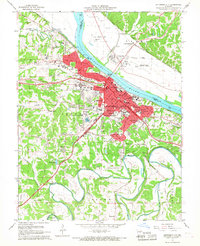
1967 Map of Jefferson City
USGS Topo · Published 1968About this map
Jefferson City stands at a critical bend in the Missouri River in this 1960s survey, showing its dual character as a center of state administration and a river-rail industrial hub. The city's landscape is dominated by institutional landmarks, including the prominent Capitol complex, the sprawling State Penitentiary along the riverbanks, and the campus of Lincoln University. Transportation is defined by the heavy presence of the Missouri Pacific and Missouri Kansas Texas railroads, which parallel the river's path. Across the water, the smaller settlements of Cedar City and North Jefferson sit near the State Prison Farm, highlighting the distinct separation between the urban capital and the lower-lying agricultural and correctional lands to the north. Rugged hills to the south and west are dotted with neighborhood institutions like Helias High School and several family and parish cemeteries, including St Peters Cem and Rouschelbach Cem.
Find a feature on this map
73 named features on this map. Tap any name to fly to it.
Don’t see what you’re looking for? This feature index may not catch every label — zoom into the map to look around manually.
Map Details
Editions of this 1967 Jefferson City Map
4 editions found
Other maps of this area

1886 · Jefferson City
USGS Topo · 1:125,000

1888 · Tuscumbia
USGS Topo · 1:125,000

1894 · Tuscumbia
USGS Topo · 1:125,000

1894 · Jefferson City
USGS Topo · 1:125,000

1939 · Jefferson City
USGS Topo · 1:24,000

1939 · Jefferson City
USGS Topo · 1:62,500

1942 · Jefferson City
USGS Topo · 1:62,500

1947 · Jefferson City
USGS Topo · 1:250,000

1948 · Centertown
USGS Topo · 1:62,500

1948 · Meta
USGS Topo · 1:62,500
Featured Places
- Jefferson City, MO
- Holts Summit, MO
- Wardsville, MO
- Cole Junction, Jefferson City
- North Jefferson, Jefferson City