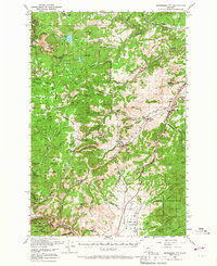
1950 Map of Jefferson City
USGS Topo · Published 1967About this map
Jefferson City and its surrounding mining districts define this mid-century view of the mountainous Divide region between the Helena National Forest and Deerlodge National Forest. The landscape is densely packed with lode mining history, featuring concentrated workings such as the Bluebird Mine, Hattie Ferguson Mine, and the Washington Mines near Wickes. The industrial infrastructure of the era is evident in the Great Northern and Northern Pacific railroads that navigate the steep grades of the Occidental Plateau and Gregory Mountain.
Find a feature on this map
87 named features on this map. Tap any name to fly to it.
Don’t see what you’re looking for? This feature index may not catch every label — zoom into the map to look around manually.
Map Details
Editions of this 1950 Jefferson City Map
5 editions found

Other maps of this area

1886 · Fort Logan
USGS Topo · 1:250,000

1889 · Helena
USGS Topo · 1:250,000

1893 · Helena
USGS Topo · 1:250,000

1899 · Boulder
USGS Topo · 1:125,000

1899 · Helena
USGS Topo · 1:62,500

1899 · Helena
USGS Topo · 1:250,000

1903 · Helena
USGS Topo · 1:250,000

1947 · Butte
USGS Topo · 1:250,000

1948 · White Sulphur Springs
USGS Topo · 1:250,000

1950 · Devils Fence
USGS Topo · 1:62,500