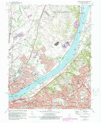
1982 Map of Jeffersonville
USGS Topo · Published 1987About this map
The Ohio River forms the central spine of this mid-1980s landscape, connecting the industrial and residential growth of Jeffersonville, Indiana, with the expanding suburbs of Louisville, Kentucky. The map documents a complex urban-rural interface, where the massive US Military Reservation Indiana Army Ammunition Plant and Clark County Airport occupy significant acreage north of the river. The Kentucky side reveals a dense network of post-war residential enclaves such as Indian Hills and Rolling Fields, alongside significant cultural sites like the Locust Grove Historic Home and the Zachary Taylor National Cem. Substantial riverfront infrastructure is evident, including the Municipal Harbor and several pumping stations, reflecting the area's continued reliance on the waterway for both transport and utility. The inclusion of the Kentucky Railway Museum and several Conrail lines highlights the region's enduring role as a major Midwestern transportation nexus.
Find a feature on this map
163 named features on this map. Tap any name to fly to it.
Don’t see what you’re looking for? This feature index may not catch every label — zoom into the map to look around manually.
Map Details
Editions of this 1982 Jeffersonville Map
2 editions found
Other maps of this area

1905 · Prospect
USGS Topo · 1:62,500

1907 · Louisville
USGS Topo · 1:62,500

1909 · Kosmosdale
USGS Topo · 1:48,000

1912 · Prospect
USGS Topo · 1:62,500

1912 · Kosmosdale
USGS Topo · 1:62,500

1937 · Jeffersonville
USGS Topo · 1:24,000

1937 · Charlestown
USGS Topo · 1:24,000

1938 · Owen
USGS Topo · 1:24,000

1938 · Speed
USGS Topo · 1:24,000

1939 · New Albany
USGS Topo · 1:24,000