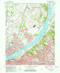
1982 Map of Jeffersonville
USGS Topo · Published 1982About this map
Ohio River crossings and riverfront industries dominate this 1982 perspective of the border between Jeffersonville, Indiana, and Louisville, Kentucky. The map documents a dense urban and suburban landscape, featuring the sprawling US Military Reservation Indiana Army Ammunition Plant north of Utica and the federal presence at the US Census Bureau in Jeffersonville. On the Kentucky side, the terrain rises into affluent residential enclaves like Glenview Heights and Windy Hills, while the historic Zachary Taylor National Cem and the VA Hospital mark the interior of the city. Transportation networks are highly developed, showing the Conrail and Southern rail lines intersecting the river, alongside the numerous bridges connecting the two states. The mapping also highlights specialized institutions such as the Sacred Heart Academy and Trinity High Sch, reflecting the community's established social infrastructure during the early 1980s.
Find a feature on this map
102 named features on this map. Tap any name to fly to it.
Don’t see what you’re looking for? This feature index may not catch every label — zoom into the map to look around manually.
Map Details
Editions of this 1982 Jeffersonville Map
2 editions found
Other maps of this area

1905 · Prospect
USGS Topo · 1:62,500

1907 · Louisville
USGS Topo · 1:62,500

1909 · Kosmosdale
USGS Topo · 1:48,000

1912 · Prospect
USGS Topo · 1:62,500

1912 · Kosmosdale
USGS Topo · 1:62,500

1937 · Jeffersonville
USGS Topo · 1:24,000

1937 · Charlestown
USGS Topo · 1:24,000

1938 · Owen
USGS Topo · 1:24,000

1938 · Speed
USGS Topo · 1:24,000

1939 · New Albany
USGS Topo · 1:24,000