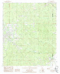
1985 Map of Jena East
USGS Topo · Published 1985About this map
The town of Jena serves as the focal point for this mid-1980s survey, marking the eastern edge of the community at the intersection of local roads and the winding Hair Creek. The landscape transition from the established settlement of Jena into the creek-carved terrain of La Salle Parish and Catahoula Parish reveals a history tied to the land's natural resources and drainage patterns. Industrial activity is evident near the parish line, where a Gravel Pit is situated among the ridges.
Find a feature on this map
20 named features on this map. Tap any name to fly to it.
Don’t see what you’re looking for? This feature index may not catch every label — zoom into the map to look around manually.
Map Details
Editions of this 1985 Jena East Map
This is the sole edition of this map. No revisions or reprints were ever made.
Other maps of this area

1941 · Manifest
USGS Topo · 1:62,500

1941 · Jena
USGS Topo · 1:62,500

1941 · Harrisonburg
USGS Topo · 1:62,500

1953 · Alexandria
USGS Topo · 1:250,000

1953 · Natchez
USGS Topo · 1:250,000

1955 · Alexandria
USGS Topo · 1:250,000

1955 · Olla
USGS Topo · 1:62,500

1956 · Natchez
USGS Topo · 1:250,000

1958 · Jena
USGS Topo · 1:62,500

1959 · Natchez
USGS Topo · 1:250,000