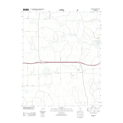
2012 Map of Jericho
USGS Topo · Published 2012About this map
Jericho stands as a focal point in this Donley County landscape, situated along the southern edge of a dissected plateau where the Texas Panhandle begins its gradual transition. The terrain is defined by the dendritic drainage patterns of McClellan Cr and its tributaries, including Apple Orchard Cr and Carrol Cr. These watercourses carve into the surrounding plains, leading toward the recreation area at Lake McClellan and the McClellan Campground in the northeast. This 2012 survey captures the modern road network, where the east-west corridor of Interstate 40 and its Frontage Rd bisect the quadrangle, superseding the older path of local routes like Co Road B. For those researching local history, the map precisely locates the Jericho Cem and Boydston Cem, providing essential coordinates for genealogical study in this sparsely populated cattle-country environment.
Find a feature on this map
27 named features on this map. Tap any name to fly to it.
Don’t see what you’re looking for? This feature index may not catch every label — zoom into the map to look around manually.
Map Details
Editions of this 2012 Jericho Map
This is the sole edition of this map. No revisions or reprints were ever made.
Other maps of this area

1954 · Amarillo
USGS Topo · 1:250,000

1958 · Amarillo
USGS Topo · 1:250,000

1960 · Groom
USGS Topo · 1:62,500

1962 · Roach Ranch
USGS Topo · 1:24,000

1962 · Griffin Ranch
USGS Topo · 1:24,000

1964 · Jericho
USGS Topo · 1:24,000

1964 · Rockledge
USGS Topo · 1:24,000

1966 · Grandview School
USGS Topo · 1:24,000

1968 · Taylor Ranch
USGS Topo · 1:24,000
1968 · Deep Lake
USGS Topo · 1:24,000